Shane Sookhan
Scientist
About

I am a scientist, software developer, and educator dedicated to creating innovative solutions for complex environmental challenges. My experience spans research, where I explore cutting-edge AI-based technologies for working with large remote sensing datasets; software development, where I develop interactive data visualization materials and powerful geospatial analytical research tools; and education, where I create unique geospatial-based experiential learning opportunities. Through this interdisciplinary approach, I aim to positively influence society by advancing our understanding and management of environmental issues.
- City: Toronto, Canada
- Email: shane dot sookhan at altitudeintellect dot com
- Hobbies: Soccer, Reading, Bass Guitar, Travelling
- Interests: Geospatial Analysis, Data Visualization, Environmental Science
As the founder of Altitude Intellect, I provide consultancy services in the development of geospatial analysis tools, geospatial data visualization tools, and landscape mapping. My role involves leveraging advanced technologies to deliver innovative solutions tailored to the unique needs of each client, driving impactful projects and fostering sustainable practices. For business inquires please visit altitudeintellect.com or contact me at shane dot sookhan at altitudeintellect dot com.
Resume
Summary
Shane Sookhan
- Location: Toronto, Ontario, Canada
- Nationality: Canadian Citizen
- Language: English
Education
Doctor of Philosophy in Environmental Science
2015 - 2022
University of Toronto, Canada
Master of Environmental Science
2014 - 2015
University of Toronto, Canada
Thesis: LiDAR-based volume assessment of the origin of the Wadena drumlin field
Honours Bachelor of Science, Environmental Geoscience
2009 - 2014
University of Toronto, Canada
Selected Academic Work Experience
Postdoctoral Researcher
2023 - 2024
University of Toronto Scarborough, Toronto, Canada
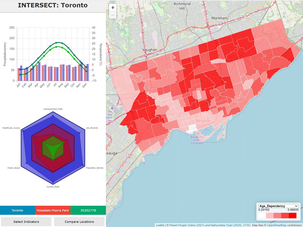
- Led development of INTERSECT, a research project investigating the spatial relationship between climate and socio-economic data
- Developed data-crawling and geostatistical tools using Python and GIS for producing indicators to assess community wellbeing
Sessional Instructor
2023 - 2024
University of Toronto Scarborough, Toronto, Canada
- Department of Human Geography, Fundamentals of GIS I
- Developed and delivered engaging course material on the fundamentals of Geographic Information Systems (GIS).
Research Assistant
2015 - 2022
University of Toronto Scarborough, Toronto, Canada
- Developed GIS-based techniques to improve the mapping of formerly glaciated landscapes from remote sensing data to predict effects of global climate change
- Pre-existing remote sensing datasets supplemented using UAV remote sensing (LiDAR and photogrammetry)
- Data analysis skills and software used include Python (Scikit-learn, TensorFlow, arcpy), R (ggplot, caret package), machine learning (neural network analysis, unsupervised image segmentation), classification (fuzzy logic, decision tree), ArcGIS (spatial statistics)
Selected Professional Work Experience
Senior Geospatial Developer
2024 - Present
Confluvio Consulting, Montreal, Canada
- Contribution to design and creation of interactive web tools developed using VueJS, Firebase, JavaScript, MapBox GL JS, and other libraries
- ArcGIS PRO tool development and documentation writing, including processing global datasets using developed tools
- Preparation of GIS training materials and delivery of GIS training sessions to customers as needed
Founder and Lead Consultant
2022 - Present
Altitude Intellect, Toronto, Canada
- Responsible for responding to request for proposals and generating funding for project development
- Services offered include the development of geospatial analysis tools, geospatial data visualization tools, training material and landscape mapping
- Current projects include development of geospatial analysis tools for mineral exploration in Canada’s North and development of geospatial data hub for interactive teaching web app
Software Developer
2021 - 2022
PRISM Institute, Mississauga, Canada
- Lead developer on ComeAI, a web app which allows user manipulation of Bayesian model parameters to provide information on socio-economic risk factors influenced by environmental data to stakeholders
- Responsible for Postgres (Supabase), HTML, CSS and JavaScript (including Vue.js) development
- Included the geocoding of web-scraped open-source socio-economic data (World Bank, etc.) for use in Leaflet map-UI element for selection of model parameters
Quaternary Geologist and Data Modeller
2021 - 2022
Natural Resources Canada, Ottawa, Canada
- Developed geospatial analysis methods for mapping and differentiating glacial activity regimes from remote sensed data
- Acquired and assembled LiDAR-based Digital Elevation Model data for study area in south Baffin Island
- Geospatial analysis completed using Python scripts with mapping done in ArcMap and ArcGIS Pro
Software Developer
2012 - 2021
University of Toronto Scarborough, Toronto, Canada
- Lead developer for Let's Rock Ontario Android App and website. Instructional Design lead for Planet Earth Online, a government funded (ecampusOntario) online course used by over 2000 students a year and Virtual Petrography, an online tool for teaching microscopy
- • Learning objects coded using Javascript, Python, CSS, JQuery and HTML. All learning objects developed to meet Web Content Accessibility Guidelines (WCAG)
- Geospatial web development packages used include Leaflet, TileMill, PanolensJS, and ArcGIS StoryMaps
- Design and Course Development software used includes Adobe Photoshop, Illustrator, and Captivate, and Blender
Portfolio
Here are a few publically available projects that I've worked on:
- All
- App
- Research
- Teaching
Research
Goals
- Develop diverse state-of-the-art geospatial analysis tools and approaches to solve both research and real-world problems related to our changing environment
- Explore cutting-edge technologies (Unmanned Aerial Vehicle data collection, Neural Network Image Analysis, etc.) and their applications to interdisciplinary research in environmental science
Recent advances in remote sensing such as LiDAR and Unmanned Aerial Vehicle (UAV) technology have led to the proliferation of easily accessible high-resolution geospatial datasets that describe our landscape in an unprecedented level of detail. My research focuses on the development and application of cutting-edge geospatial data analysis and AI-driven methods needed to acquire, prepare, integrate, and analyze such ‘big data’ to solve complex environmental challenges. I am developing geostatistical and neural network image analysis-based tools to classify and detect objects from high-resolution satellite imagery and digital elevation models (DEMs); exploring the use of unsupervised machine learning algorithms and clustering techniques to better understand systematic patterns in such datasets; and using UAV equipment to acquire and prepare datasets in under-surveyed areas. Additionally, I am investigating how these environmental datasets can be integrated with socio-economic indicators to provide a more comprehensive understanding of community wellbeing.
Refereed publications (Mentored co-authors are underlined with UndergradU, GraduateG)
Sookhan, S., Paulen, R., Zajch, A., Tremblay, T., and Eyles, N. Reconstructing glaciodynamic behaviour using surface-based roughness analysis of high-resolution digital elevation model data in Southern Baffin Island, Nunavut, Canada and the Peterborough, Ontario, Canada. Earth Surfaces Processes and Landforms, In Prep.
Sookhan, S., and Eyles, N. Glaciological structure of a surge-induced Late Wisconsin paleo-ice stream: Two Medicine Glacier, eastern Rocky Mountains, Montana, USA. Geological Society of America Bulletin, In Prep.
Paulen, R., Sookhan, S., Tremblay, T., and Eyles, N. Median flow-directional roughness of study area in Southern Baffin Island, Nunavut, Canada. Journal of Maps, In Prep.
Sookhan, N., Sookhan, S., and MacIvor, J. Automating field based multi-species floral surveys with computer vision. Methods in Ecology and Evolution, In Prep.
Sookhan, S., Eyles, N., and Bukhari, S.U (2023).Response to comments by Karig (2021) on Sookhan et al. "Lidar-based quantitative assessment of drumlin to mega-scale glacial lineation continuums and flow of the paleo Seneca-Cayuga paleo-ice stream". Quaternary Science Reviews 305, 107451.
Eyles, N., Bukhari, S.G, Sookhan, S., Ruscica, P.G, and Paulen, R. (2023). LiDAR‐based semi‐automated mapping of drumlins and mega‐scale glacial lineations of the Green Bay Lobe, Wisconsin, USA: ice sheet beds as glaciotribological systems. Earth Surface Processes and Landforms 48 (2), 295-321.
Sookhan, S. (2022). Exploring the Glaciodynamic Significance and Origin of Drumlins and Mega-Scale Glacial Lineations from High-Resolution Topographic Imagery. University of Toronto (Canada).
Sookhan, S., Eyles, N., and Bukhari, S.U (2022). Drumlins and mega-scale glacial lineations as a continuum of subglacial shear marks: A LiDAR based morphometric study of streamlined surfaces on the bed of a Canadian paleo-ice stream. Quaternary Science Reviews, 292, 107679.
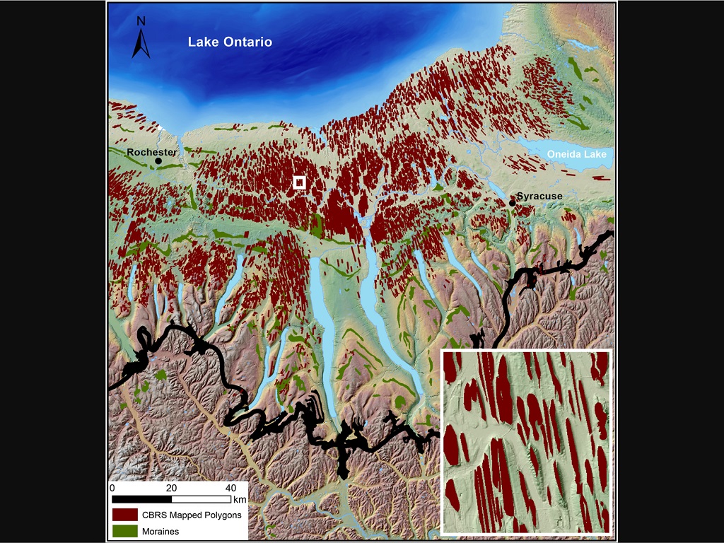
Sookhan, S., Eyles, N., Bukhari, S.U, and Paulen, R. (2021) LiDAR-based quantitative assessment of drumlin to mega-scale glacial lineation continuums and flow of the paleo Seneca-Cayuga paleo-ice stream. Quaternary Science Reviews, 263, 107003.
Zhou, W., Eyles, N., Sookhan, S., and Putkinen, N. (2021). Glaciotribology of drumlins and megascale glacial lineations: an enigma solved? Dizhi Xuebao/Acta Geologica Sinica, 95(8), 2306-2317.
Sookhan, S., Eyles, N., Bukhari, S.U, and Paulen, R. (2021) LiDAR-based quantitative assessment of drumlin to mega-scale glacial lineation continuums and flow of the paleo Seneca-Cayuga paleo-ice stream. Quaternary Science Reviews, 263, 107003.
Sookhan, S., Eyles, N., and Arbelaez-Moreno, L.U (2019). Reply to the comment by HAJ Russell on “Converging ice streams: a new paradigm for reconstructions of the Laurentide Ice Sheet in southern Ontario and deposition of the Oak Ridges Moraine”. Canadian Journal of Earth Sciences, 56(8), 889-893.
Sookhan, S., Eyles, N., and Putkinen, N. (2018). LiDAR-based mapping of paleo-ice streams in the eastern Great Lakes sector of the Laurentide Ice Sheet and a model for the evolution of drumlins and MSGLs. GFF, 1-27.
Sookhan, S., Eyles, N., and Arbelaez-Moreno, L.U (2018). Converging ice streams: a new paradigm for reconstructions of the Laurentide Ice Sheet in southern Ontario and deposition of the Oak Ridges Moraine. Canadian Journal of Earth Sciences, 55(4), 373-396.
Eyles, N., Moreno, L.U, and Sookhan, S. (2018). Ice streams of the Late Wisconsin Cordilleran Ice Sheet in western North America. Quaternary Science Reviews, 179, 87-122.
Eyles, N., Putkinen, N., Sookhan, S., and Arbelaez-Moreno, L.U (2016). Erosional origin of drumlins and megaridges. Sedimentary Geology, 338, 2-23.
Sookhan, S., Eyles, N., Putkinen, N. (2016). LiDAR-based volume assessment of the origin of the Wadena drumlin field, Minnesota, USA. Sedimentary Geology, 338, 72-83.
Yu, P.G, Eyles, N., Sookhan, S. (2015). Automated drumlin shape and volume estimation using high resolution LiDAR imagery (Curvature Based Relief Separation): A test from the Wadena Drumlin Field, Minnesota. Geomorphology, 246, 589-601.
Peer-reviewed conference proceedings
Eyles, N., Mulligan, R., Paulen, R., and Sookhan, S. (2018). Subglacial bedforms in southern Ontario: from flood paths to flow sets: AMQUA-CANQUA Post-conference field trip guidebook, August 2018.
Invited Talks and Conference Presentations (12; Mentored co-authors are underlined with UndergradU)
Sookhan, S., Eyles, N., Bukhari, S.U, and Paulen, R. (2021) LiDAR-based quantitative assessment of drumlin to mega-scale glacial lineation continuums and flow of the paleo Seneca-Cayuga paleo-Ice Stream. Oral Presentation. GAC-MAC 2021; 2021 November; Online.
Sookhan, S. (2020). Planet Earth Online: Project Update and Experiences. Presented at: Sharing Online Teaching Ideas Meeting; 2020 May 21; Department of Physical and Environmental Sciences, University of Toronto, Canada.
Sookhan, S., Eyles, N. (2020). Field Experiences. Presented at: Adapting Experiential Learning for Remote Delivery Webinar Series; 2020 July 8; Office of the Vice-Provost, Innovations in Undergraduate Education, University of Toronto, Canada.
Sookhan, S. (2020). What machine learning tells us about ancient ice sheets. Oral Presentation. Centre for Planetary Sciences colloquium; 2020 March 13; University of Toronto, Toronto, Canada.
Sookhan, S., Eyles, N. (2019). Erosional origin of sediment-cored drumlins and megascale glacial lineations: upper tills as thickened erodent layers. Oral Presentation. 20th Congress of the International Union for Quaternary Research; 2019 July 25-31; Dublin, Ireland.
Sookhan, S., Eyles, N. (2019). Drumlin Mapping Using Deep Learning Object Detection Systems. Poster presented at: Drumlins - studies of a persisting enigma. 20th Congress of the International Union for Quaternary Research; 2019 July 25-31; Dublin, Ireland.
Sookhan, S., Eyles, N. (2019). Glaciological structure of a surge-induced Late Wisconsin paleo-ice stream: Two Medicine Glacier, eastern Rocky Mountains, Montana, USA. Poster session presented at: Palaeo-Ice streams: Forms, processes and palaeoglaciology. 20th Congress of the International Union for Quaternary Research; 2019 July 25-31; Dublin, Ireland.
Sookhan, S., Eyles, N. (2019). Drumlin Mapping Using Deep Learning Object Detection Systems. Oral presentation. 5th Doctoral Environmental Science Colloquium; 2019 May 2-3; University of Toronto, Toronto, Canada.
Sookhan, S., Eyles, N. (2017). Exploring the origins of drumlins and megascale glacial lineations. Poster session presented at: Glacial Processes and Deposits: Advances and Applications. 2017 GAC-MAC annual meeting; 2017 May 14-18; Queen's University, Kingston, Canada.
Sookhan, S., Eyles, N. (2017). Exploring the origins of drumlins and megascale glacial lineations. Oral presentation. 3rd Doctoral Environmental Science Colloquium; 2017 May 7-8; University of Toronto, Toronto, Canada.
Eyles, N., Sookhan, S., Putkinen, N. (2015). Erosional Origin for Drumlins by Subglacial Erodent Layers: A Tribological Model. Oral Presentation. 2015 AGU-GAC-MAC-CGU Joint Assembly; 2015 May 3-7; Montreal, Canada.
Sookhan, S., Gao, R. (2013). The technological present is the key to the past: Using mobile and web devices to teach Geosciences. Presented at: Facies analysis revisited: into the third and fourth dimension; 2013 November 8; McMaster University, Hamilton, Canada.
Contributed (7; Mentored co-authors are underlined with UndergradU, GraduateG)
Daxberger, H., Kennedy, K., Sookhan, S., Moumblow, R. (2021) Comparing student learning achievements using traditional versus virtual microscopes for Mineralogy and Petrology. Oral Presentation. GAC-MAC 2021; 2021 November; Online.
Daxberger, H., Kennedy, K., Sookhan, S., Moumblow, R. (2021) Virtual Petrography - Expanding the Microscope Laboratory with a New Interactive Online Tool. Oral Presentation. Earth Educators' Rendezvous; 2021 July; Online.
Bukhari, S.U, Sookhan, S., Eyles, N., Paulen, R. (2020) Geomorphology of a Late Wisconsin Hard-Bedded Ice Stream Landsystem, Ontario, Canada Revealed by High-Resolution LiDAR Mapping. Oral Presentation. GSA 2020 Connects Online; 2020 January; Online.
Ruscica, P.U, Eyles, N., Sookhan, S., Bukhari, S.U (2020) Erosionally-streamlined Subglacial Bedforms, and Ice Marginal Pressed Moraines on the Bed of a Paleo Ice Stream: Green Bay Lobe, Wisconsin USA: Lidar Mapping of a Soft-bed Ice Stream Landsystem. Oral Presentation. GSA 2020 Connects Online; 2020 January; Online.
Eyles, N., Sookhan, S. (2017). The Oak Ridges Moraine was deposited between two fast-flowing ice streams. Oral Presentation. 2017 GAC-MAC annual meeting; 2017 May 14-18; Queen's University, Kingston, Canada.
Arbelaez-Moreno, L.U, Eyles, N., Sookhan, S. (2017). Ice streams within the last Cordilleran Ice Sheet. Poster session presented at: Glacial Processes and Deposits: Advances and Applications. 2017 GAC-MAC annual meeting; 2017 May 14-18; Queen's University, Kingston, Canada.
Sookhan, S., Eyles, N., Putkinen, N. (2015). LiDAR-based Volume Assessment of the Wadena Drumlin Field and End Moraines, Minnesota, USA: Evaluating an Erosional Origin for Megascale Glacially Lineated Terrains. Poster session presented at: Ice stream bed processes. 2015 AGU-GAC-MAC-CGU Joint Assembly; 2015 May 3-7; Montreal, Canada.
Contact
Feel free to contact me at shane dot sookhan at altitudeintellect dot com